Bosphorus

site
Map or image for Bosphorus

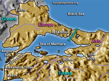
The Bosphorus Strait is an 18.5 mi. [30 km.] long waterway that connects the Black Sea in the north with the Sea of Marmara to the south. It is the body of water that separates Asia from Europe!

Its width varies from 0.5 to 2.8 mi. [660 to 4,500 m.] and its depth from 165 to 650 ft. [50 to over 200 m.]. The surface current flows from north to south while the undercurrent flows from south to north.

Given the importance of Black Sea ports (including oil pipeline terminals) this connection to the Mediterranean Sea is of inestimable strategic importance.

Bosphorus means “Ford of the Cow,” and it derives its name from a Greek myth that recounts that the god Zeus tried to conceal his lover “Io,” as a cow, in it in order to escape the wrath of his wife Hera!


Photos (23)

Dolmabahce Mosque
Dolmabahce Mosque
Dolmabahce Palace
Dolmabahce Palace
Dolmabahce Palace Detail
Ciragan Palace
Ciragan Palace
Mecidiye Mosque
Mecidiye Mosque
Fishing Boat
Fishing Boat
Fortress of Europe
Fortress of Europe
Bosphorus
Bosphorus
Fortress of Europe
Fortress of Europe
Fatih Sultan Mehmet Bridge
Villas
Villas
Ship
Ship
Leander’s Tower
Leander’s Tower
Hagia Sophia
Hagia Sophia
Topkapi Palace
Topkapi Palace
Suleymaniye Mosque
Suleymaniye Mosque
Aerial
Aerial
Golden Horn meets Bosporus
Bosporus and Golden Horn
Bosporus and Sea of Marmara
Bosporus
Bosporus
Ortaköy Mosque
Ortaköy Mosque
Mansion Hit by Ship
Mansion Hit by Ship
Keywords: Bosphorus, Bosporus, Istanbul, Constantinople, Byzantium, Straits, Strait, Map Maps, Turkey, West, Marmara Region