Megiddo (Bronze Age)

site
Map or image for Megiddo (Bronze Age)

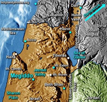
The mound of Megiddo is situated in northern Israel on southwestern edge of the Jezreel Valley. It controls a pass that leads through Mt. Carmel and thus it was of considerable strategic importance. Four different excavations of Megiddo have been mounted since 1903 up through the present.

It is 15 acres [6 ha.] in size. Over 20 strata (levels of civilization) have been found at the site.


To view remains of Israelite Megiddo Click Here.

Photos (12)

Middle/Late Bronze Gate 2
Ivory Plaque
Ivory Plaque
Eastern Trench
Eastern Trench
Circular Altar
Circular Altar
Sacred Area
Sacred Area
Early Bronze Age Temple
Sacred Area Temple
Sacred Area Temple
Sacred Area Temple (Labeled)
Square Altar
Square Altar
Chalcolithic Temple
Chalcolithic Temple
Megiddo from the East
Middle/Late Bronze Gatea
Keywords: Megiddo, Bronze Age, Map Maps, Photos, Images, PowerPoint